IDENTIFICATION OF COLORANTS ON MAPS FROM THE EARLY COLONIAL PERIOD OF NEW SPAIN (MEXICO)MARY ELIZABETH HAUDE
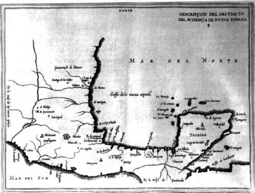
3 RELACIONES GEOGR�FICAS3.1 HISTORYThe RG are a group of maps and manuscripts created during the early colonial period in response to a questionnaire developed for Philip II of Spain to survey the diverse regions of New Spain (Mexico), Central America, South America, and the Spanish West Indies during the years 1578–85. To date, Barbara Mundy's The Mapping of New Spain: Indigenous Cartography and the Maps of the Relaciones Geogr�ficas (1996) is the most definitive source on these particular New Spanish maps. Mundy thoroughly discusses the history of these maps and their manufacture through a joint effort of Spanish colonists and indigenous Mexicans. Juan L�pez de Velasco, Spain's cosmographer-chronicler of the New World colonies, devised the 50-item RG questionnaire and sent it to New Spain in 1578 (Mundy 1996). The questionnaire was widely distributed to Spanish officials in various regions of the newly founded Spanish colonies. The questions sought information on political jurisdiction, terrain, language affiliation, Native traditions, plant names, and mineral sources. In addition to the survey questions, a map of each region, called a pintura (painting, picture), was required (Cline 1972). Mundy (1996) indicates that answers to the questions were almost always supplied by Spanish administrators, but the majority of the maps were made by indigenous painters. She further emphasizes that these painters were likely of the Native nobility because painting was considered an elite vocation by pre-Columbian Mexicans. Catholic priests in New Spain continued training the indigenous elites to write and paint in the postconquest period. While the texts of the RG questionnaire were often signed by the respondents, only three maps were signed by the artists. In some instances, the respondents of the texts identify the artists of the corresponding maps. The author of the Relacion Geogr�fica of Ixtapalapa identifies the painter Mart�n Cano as an indigenous resident of Ixtapalapa (Mundy 1996); the Ixtapalapa map is discussed in this article. Mundy has identified other mapmakers by careful study of “individual drawing styles in order to correlate the author of the map to a particular scribe or signatory of the text” (31). Again, she believes that most of the maps were drawn by indigenous artists. The RG maps vary in artistic style from Native to European Renaissance. Many of the maps show neither predominately indigenous nor European conventions, but rather a blending of both artistic styles. Many of the indigenous artists responsible for creating the maps were trained in the art of writing and painting at monastic schools in New Spain. Native artists were taught European artistic conventions by copying graphic images from European prints available at the monasteries. Mundy emphasizes that prints also introduced these artists to illusionism where “painting should mimic visual experience” (Mundy 1996, 77). The inclusion of Native elements in the maps partly resulted from the rich pre-Columbian tradition of painting and writing. 3.2 PROVENANCECline (1972) estimates that of the 283 RG items recorded for New Spain, including texts and maps, 243 are extant. RG collections currently exist in three institutions, including the Benson Latin American Collection of UT-Austin, the Real Academia de la Historia in Madrid, and the Archivo General de Indias in Seville. The RGs began arriving in Spain in 1583 and, once there, were relocated several times. In 1787, the Archivo General de Indias in Seville obtained 80 texts and 22 maps (Cline 1972, 197). Cline indicates that nearly half of the RGs were lost between 1783 and 1853. In 1853, a portion of the lost manuscripts were purchased by Juaqu�n Garc�a Icazbalceta and moved from Spain to Mexico. Luis Garc�a Pimentel inherited the book and manuscript collection of Icazbalceta, his father, in 1894. In 1937 the family sold the collection, including the RGs, to UT-Austin (Cline 1972, 199–200). Currently, the Benson Latin American Collection houses 43 manuscripts and 37 RG maps. The Real Academia de la Historia in Madrid acquired approximately 46 of the aforementioned lost manuscripts in 1863 (Cline 1972, 200). 3.3 INDIVIDUAL RG MAPSThe six maps treated at the PCS laboratories include Ameca, Atlatlauca, Cholula, Ixtapalapa (fig. 1, p. 245), Meztitlan, and Tehuantepec. They represent a broad geographic sample of New Spain. Figure 2 (p. 246) is an early-17th-century map that shows the boundaries of New Spain. Geographically, the maps range from the west coast of the Pacific (Ameca in present-day Jalisco state), to the Valley of Mexico (Atlatlauca and Ixtapalapa in present-day Mexico state, Cholula in present-day Puebla state, Meztitlan in present-day Hidalgo state), to the southern coast of the Pacific (Tehuantepec in present-day Oaxaca state). Typical of manuscripts from the early colonial period of New Spain, the RGs' pictorial elements combine indigenous iconographic representations and European naturalistic renderings. Because the artistic elements are a mix of Native and European conventions, an early assumption was that the pigments may also be a mix of Native and European materials.
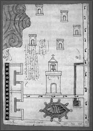
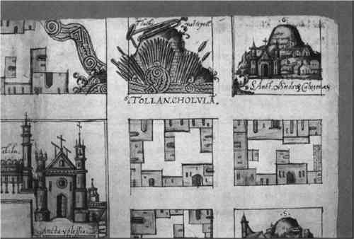
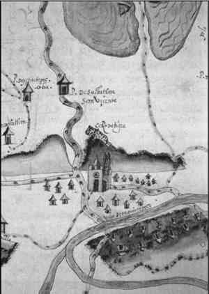
Note the conjunction of indigenous artistic influences with European conventions in the map Cholula (fig. 3, p. 246). In the Native style, a uniform outline delineates the blocks of houses, which are stylized, represented two-dimensionally and in varied perspectives, and painted with flat washes of color. Also in Cholula, the European artistic style is apparent in the block with the cathedral and mountain. A varied outline delineates and imparts mass to these pictorial elements, which are naturally rendered, represented three-dimensionally and in a unified perspective, and painted with a modulating application of color. With the exception of Meztitlan, which is wholly European influenced (fig. 4, p. 249), the maps combine Native and European artistic styles in varying degrees. It is not surprising that Meztitlan is of European convention because it was drawn by a Spanish colonist named Gabriel de Ch�vez (Mundy 1996). Table 1 (p. 265) summarizes the artistic elements of each map. While the descriptions of the artistic elements are based on my examination of the six RG maps, I found Robertson's (1972) categorization of the RGs invaluable.
TABLE 1 ARTISTIC ELEMENTS The glosses of five of the maps are in
Examination of the pictorial and written elements of the RG maps confirmed that these artifacts, as with many manuscripts created during the early colonial period of New Spain, reflect a blending of indigenous and European artistic styles. Examination of the colorants would reveal whether they, like the pictorial and written elements, also combine indigenous and European materials. 3.4 MATERIALS3.4.1 Paper SupportsThe supports of all six maps are laid rag paper, possibly Spanish-made, and the dimensions range from 31 � 42 cm to 42 � 58 cm. The examination of the paper substrates was merely visual; there was no fiber identification. An investigation of the watermarks ensued to determine the possible origins of the paper. Ameca, Atlatlauca, Cholula, and Ixtapalapa share similar watermarks of pilgrims. These watermarks were common in 16th-century Spain, Italy, and France. It is likely that the pilgrim watermark originated in the Catalan region of Spain because the earliest example of this watermark (ca. 1500) is located in the Catalan archives. The watermark of Tehuantepec is a mermaid. Mermaid water-marks were common in France, Italy, Spain, and Germany in the 15th and 16th centuries, and they probably originated in the Provence region of France (Valls I Subir� 1970). The paper support of Meztitlan has no watermark. The first New Spanish mill for making rag paper in the European tradition was established in 1575 in Culhuacan near Mexico City (Hunter 1978). The paper from the Culhuacan mill lacked a recognizable European watermark (Mundy 1996). Because the township of Meztitlan is relatively near Culhuacan, it is possible that the paper support of the Meztitlan map was manufactured 3.4.2 Paints and InksIt is difficult to differentiate paints and inks positively on the maps. By appearances, it seems that paint was used in areas of broadly applied color, in thick and thin washes. The painting material sits atop the paper's surface with little appearance of penetration. The inscriptions and many of the outlines appear to consist of black and brown ink. In these areas, the drawing material appears fluid and has penetrated the paper substrate. The brown ink is likely iron gall because of its characteristic brown color and the manner in which it has deteriorated the paper substrates in the areas of the inscriptions on several of the maps; the black ink is likely carbon-based. The colors of paints and inks on the maps include red, orange, yellow, blue, green, brown, black, and white; these vary in hue. The range of color is similar on all six maps. No map contains more than seven colors. In The Pinturas (Maps) of the Relaciones Geogr�ficas, With a Catalog, Robertson (1972) indicates that much is known about the supports (European rag paper, amatl paper, animal hides) of the RGs, but little is known about the paints and inks. |