MANAGING CHANGE: THE ROLE OF DOCUMENTATION AND CONDITION SURVEY AT MESA VERDE NATIONAL PARKFRANK G. MATERO
ABSTRACT—The approximately 600 cliff dwellings in Mesa Verde National Park in Colorado represent the apex of architectural sophistication of the Northern San Juan Ancestral Puebloan culture. The cliff dwellings, the final product of 600 years of cultural development on the Mesa Verde, were built between A.D. 1200 and 1300, and were abandoned shortly thereafter. The spectacular setting and the well-preserved state of these masonry structures and their surface finishes resulted in Mesa Verde's being the first nomination by the U.S. government to the World Cultural Heritage Sites List. Moreover, descendants of these ancient peoples, the Pueblo Indians of Arizona and New Mexico, continue to venerate these sites, representing a cultural continuity unique for North America. Excavation and preservation have been continuous since Mesa Verde became one of the first national parks in 1906. The structures interpreted to the public have been preserved over the years with a minimum of repair and replacement, resulting in a cultural resource of great integrity and authenticity.A phased conservation program to develop coordinated methods for the survey, analysis, stabilization, and interpretation of the masonry and prehistoric surface finishes in the alcovate (cliff-dwelling) sites of Mesa Verde National Park has been in progress since 1994 by the Architectural Conservation Laboratory of the University of Pennsylvania. The program has included a comprehensive method of study, including archival research, technical analysis, and characterization of the architectural materials; detailed field and digital recording of existing conditions, including environmental monitoring; and the design, testing, and execution of a treatment and protection program specifically focused on the in situ stabilization of plain and painted architectural surface finishes. Though case-study oriented, this article addresses in detail the theoretical and technical aspects of condition survey and recording as an important vehicle for material and site diagnostics, which must precede remedial and preventive interventions. Detailed information is provided on the use of current digital technology for condition survey. TITRE—G�rer le changement: le r�le de la documentation et des constats d'�tat au Parc national de Mesa Verde. R�SUM�—Les quelques 600 habitations troglodytiques du Parc national de Mesa Verde au Colorado, repr�sentent l'apog�e de la sophistication architecturale de la culture ancestrale Pueblo du San Juan du Nord. Ces habitations � flanc de falaises, ultime produit de 600 ans de d�veloppement culturel sur le Mesa Verde, furent construites entre les ann�es 1200 et 1300 apr�s J�sus-Christ, puis abandonn�es peu apr�s. Gr�ce � un site spectaculaire et au bon �tat de pr�servation des structures en ma�onnerie et de leurs rev�tements, Mesa Verde fut le premier site � �tre inscrit par le gouvernement am�ricain au patrimoine mondial de l'Unesco. De plus, les descendants de ces peuples anciens, les indiens Pueblo de l'Arizona et du Nouveau Mexique, continuent de v�n�rer ces sites, ce qui repr�sente une continuit� culturelle unique pour l'Am�rique du Nord. Depuis que Mesa Verde est devenu l'un des premiers parcs nationaux en 1906, les fouilles et les projets reli�s � la pr�servation n'ont pas fait rel�che. Ce bien culturel est d'une grande int�grit� et d'une grande authenticit� car au fil des ans, les structures accessibles au public ont �t� pr�serv�es avec un minimum de r�parations et de remplacements.Dans le but de d�velopper des m�thodes int�gr�es pour le relev�, l'analyse, la stabilisation et l'interpr�tation de la ma�onnerie et des rev�tements pr�historiques dans les sites en alc�ves (habitations troglodytiques), le Laboratoire de conservation architecturale de l'Universit� de Pennsylvanie a �labor� un programme par �tapes, qui est en cours depuis 1994. Ce programme s'est bas� sur une m�thode de recherche tr�s d�taill�e: recherche archivistique; analyse technique et caract�risation des mat�riaux architecturaux; relev�s in situ d�taill�s et num�ris�s de l'�tat de conservation actuel, incluant une �valuation de l'environnement; et enfin l'�laboration, les essais et la r�alisation d'un programme de traitement et de protection sp�cifiquement destin� � la stabilisation in situ des surfaces architecturales nues ou peintes. � l'aide d'�tudes de cas, cet article aborde en TITULO—Manejando el cambio: el rol de la documentacion y el estudio de la condicion en el parque nacional de Mesa Verde. RESUMEN—Las aproximadamente 600 alcobas edificadas en las quebradas del Parque Nacional de Mesa Verde en Colorado representan la epifan�a de la sofisticaci�n arquitect�nica de la cultura ancestral llamada San Juan Pueblo Norte. Las alcobas, producto de 600 a�os de desa-rrollo cultural en Mesa Verde, fueron edificadas entre el 1200 y 1300 AD y fueron abandonadas casi inmediatamente despu�s de su construcci�n. La espectacular escenograf�a y el buen estado de conservaci�n de estas estructuras de mamposter�a y sus coloridos enlucidos de tierra llevaron a Mesa Verde a ser el primer monumento presentado por el gobierno de los Estados Unidos de Norteam�rica para ser considerado Patrimonio Cultural de la Humanidad. Mas a�n, los Indios del Pueblo de Arizona y Nuevo M�xico, descendientes de esta cultura ancestral, contin�an venerando estos sitios; convirtiendo a Mesa Verde en un extraordinario ejemplo de continuidad cultural para Norteam�rica. Desde que Mesa Verde se convirti� en el primer Parque Nacional en 1906, una serie trabajos de excavaci�n y conservaci�n se han venido ejecutando. Las estructuras, expuestas e interpretadas para el p�blico, se han conservado en el tiempo sufriendo m�nima intervenci�n; y son consideradas fuente aut�ntica para el estudio y preservaci�n de esta cultura.Desde 1994, el Laboratorio de Conservaci�n Arquitect�nica de la Universidad de Pennsylvania viene trabajando en un programa de conservaci�n dise�ado en etapas para desarrollar metodolog�as coordinadas de investigaci�n, an�lisis, estabilizaci�n e interpretaci�n de la mamposter�a y enlucidos pre-hist�ricos de los diferentes grupos de alcobas del Parque Nacional de Mesa Verde. Este programa est� basado en una compleja metodolog�a que incluye investigaci�n de archivos hist�ricos, an�lisis t�cnicos y caracterizaci�n de materiales arquitect�nicos; detallados levantamientos de campo digitales sobre el estado de la condici�n del monumento, incluyendo monitoreo medioambiental; y el dise�o, prueba y ejecuci�n de un programa de tratamientos de intervenci�n y protecci�n especialmente enfocado a la estabilizaci�n in situ de los enlucidos pict�ricos.Presentado como un estudio de caso, el presente art�culo informa al detalle los aspectos te�ricos y t�cnicos involucrados en la investigaci�n de la condici�n del monumento. Propone el levantamiento como veh�culo importante para el diagn�stico del estado del material y del sitio, el cual debe siempre preceder a cualquier intervenci�n preventiva o de conservaci�n. El art�culo tambi�n presenta detallada informaci�n sobre el uso de tecnolog�a digital de avanzada para el estudio, diagn�stico y presentaci�n del estado de la condici�n del monumento. 1 INTRODUCTION
Since its emergence in the early 20th century as a field of intellectual inquiry and applied practice, the conservation of historic and artistic works has matured into a distinct and professionally defined discipline. This development is owing, in part, to the adoption of an etiological approach to the examination and treatment of cultural property—that is, the relational study of the causes of deterioration and interventions based on scientific method. Other disciplines such as medicine and criminology share this methodology, whereby cause and effect (e.g., pathogen and symptom or motive and crime) are explored together in an attempt to offer explanation and thereby direct action accordingly. Establishing such relationships begins with observation and description, which in the case of conservation leads to documentation. Documentation and recording are the cornerstones of conservation practice.1 Conservators perform documentation based on the belief that by recording the tangible aspects of material Traditionally, documentation for conservation has long been associated with the physical state or condition of an object or site immediately before and after intervention (AIC 2001). No doubt this connection can be attributed to the physical changes most conservation treatments effect, as well as the contributions that documentation can make toward an increased understanding of the original appearance or technology of the object or site. But it has also been through the study of existing condition as a record of past change that conservators have seen the value of documentation and recording in developing a more accurate knowledge of alteration and deterioration. This relationship is especially the case for understanding long-term trends and patterns of decay, as well as the efficacy of treatment performance and durability predictions. By studying condition as the cumulative result of change over time through scientific observation and description, one can come closer to understanding alteration mechanisms and to identifying and managing deterioration as deleterious change. The road to accurate and effective diagnosis must therefore begin with a conscious methodology employing descriptive symptomatic recording, preferably executed over time. In this way, the variables of condition type, location, extent, and severity can be observed alone, together, and in combination with other factors such as material design, including construction and composition, environment, use and modification, maintenance, and previous conservation. As Hughlings Jackson cautioned years ago, “The study of the causes of things must be preceded by the study of things caused” (quoted in Beveridge 1957, 15). In recent years, the technology for producing more accurate and comprehensive documentation has increased dramatically through the development of newer imaging and computer graphic software programs, such as AutoCAD, and Geographic Information Systems (GIS), such as ArcView, and the creation and adaptation of nondestructive investigation and monitoring apparatus (Palumbo 2000). These tools have promoted the development of condition assessment surveys as critical diagnostic vehicles that go far beyond earlier interests in recording the immediate physical status before and after treatment. As powerful graphic methods, these digital aids allow the manipulation and analysis of large data sets and long-term recording, which ultimately should result in better conservation and management decisions. However the true value of any condition survey program must begin with a clear definition of what information is required and why. All recording is deceptively subjective, always performed with a specific objective or from a particular point of view. Contrary to modern scientistic notions, it is the moment at which interpretation begins. The documentation of structures and sites and associated building arts such as mosaics, sculpture, and wall painting presents enormous difficulties attributed as much to their size and complexity as to the pressures of utility and context. Existing buildings and sites do not come to us unchanged. A great many agents and phenomena, ancient and modern, transform sites over time and in different ways. A variety of natural and cultural processes, including natural decay mechanisms and human actions, continually alter a building's fabric and form. Daily maintenance, intermittent repair, use and reuse (including ritual activity), neglect, decay, abandonment, and recovery are among the diverse yet plausible processes that translate past actions and events into present conditions. As a result, the physical condition of any structure or site is a record of the interaction of many different determinants over the course of its existence (fig. 1). For most archaeological sites these determinants include (in general order of occurrence):
These determinants characterize individual Despite the inevitable alteration that entropy effects on all matter, such material transformations are not random but patterned, reflecting the predictable consequences of natural weathering cycles and decay mechanisms. These processes can be and were altered consciously and unconsciously by human action, thus making the reading of the resultant conditions over time a diagnostic challenge, yet one filled with the potential for understanding the complex and critical relationship between cause and effect, damage and treatment, past and present. In the end, it should be possible to establish a relationship between specific causative variables, specific decay mechanisms, and regular and predictable effects learned through detailed descriptive observation, monitoring, experimentation, and historical research. Fundamental, then, to the role of condition survey as a diagnostic tool is the concept of a site or building's life history and the interpretation of condition as “accumulated evidence” of natural and cultural events mapped onto the physical form and fabric. This concept requires a reverse reading of the site or building by first observing and describing—i.e., recording and then interpreting the effects of the alterations leading to an understanding of what, where, when, how, and why such changes occurred.
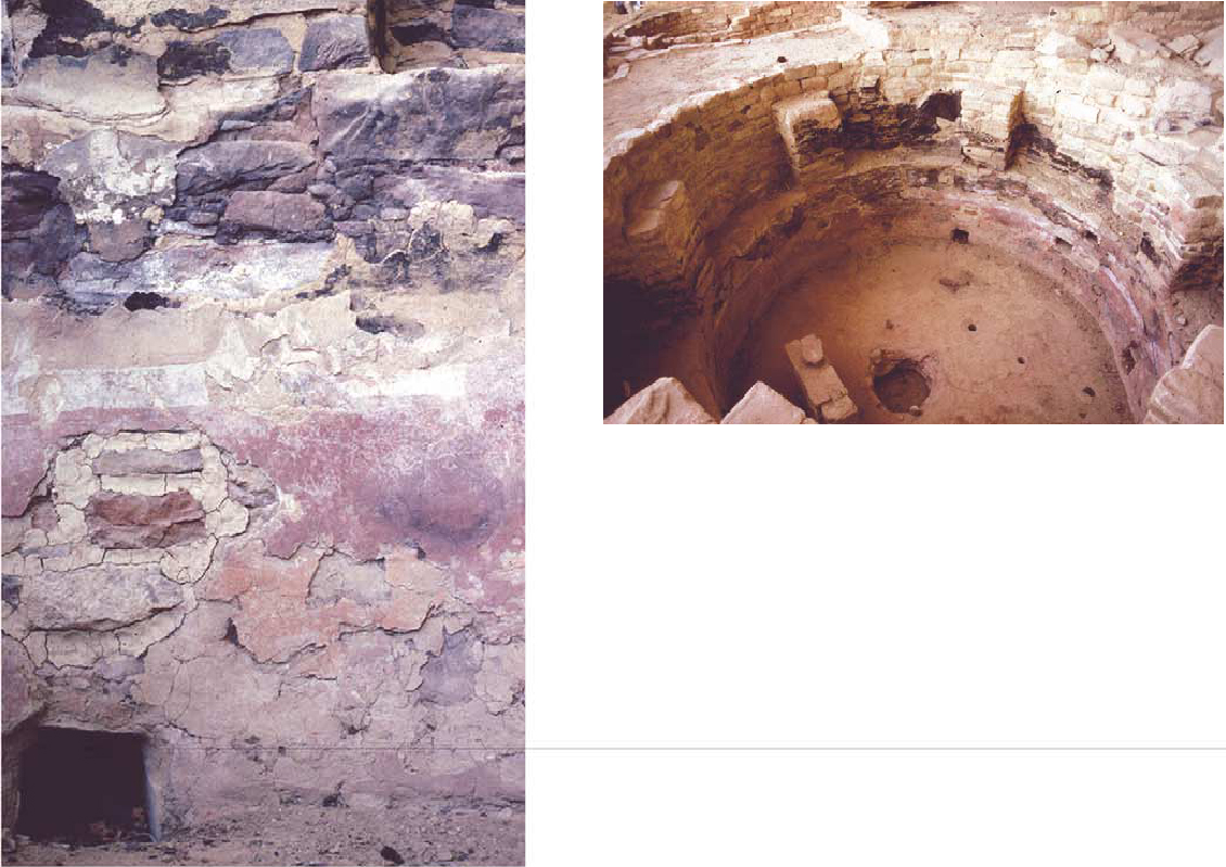
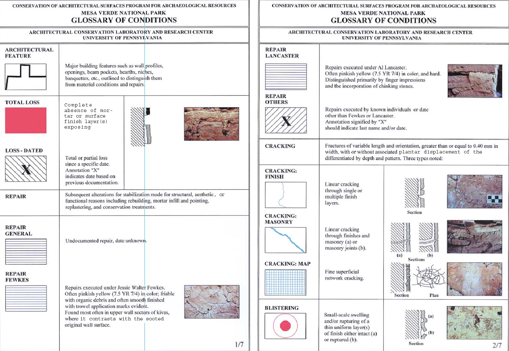
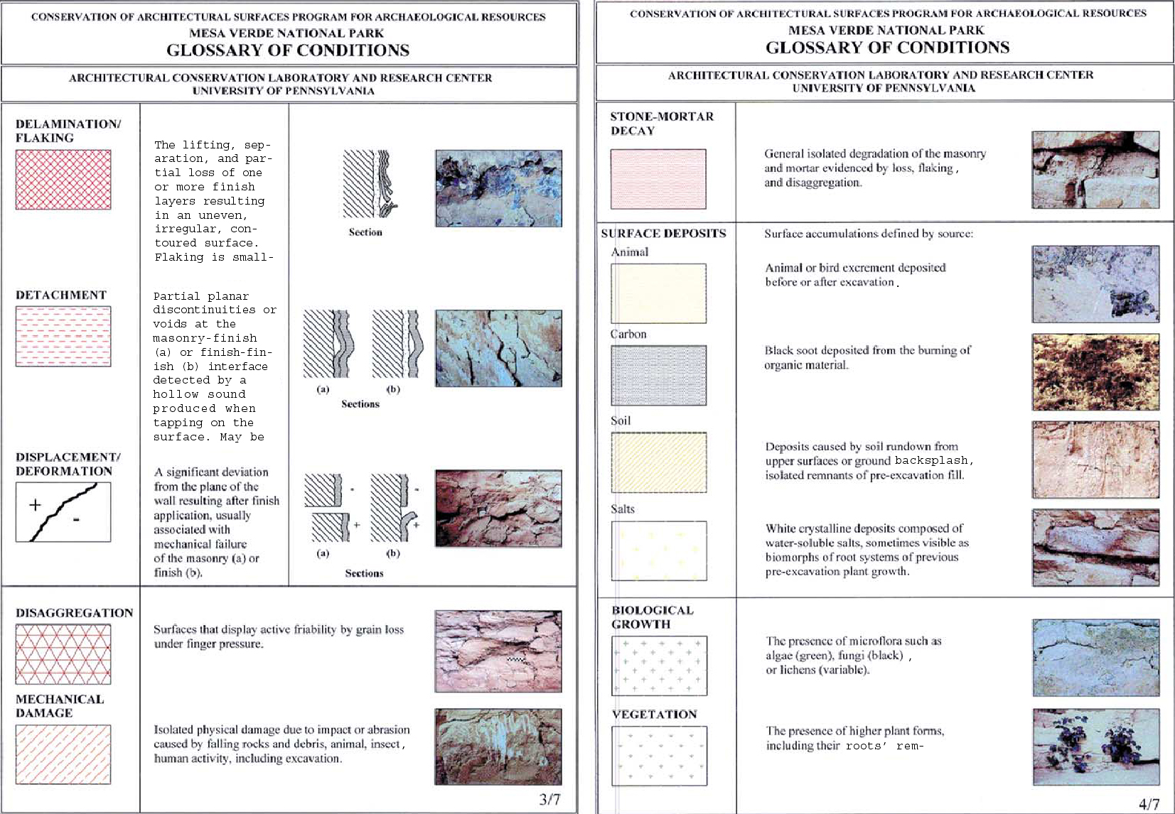
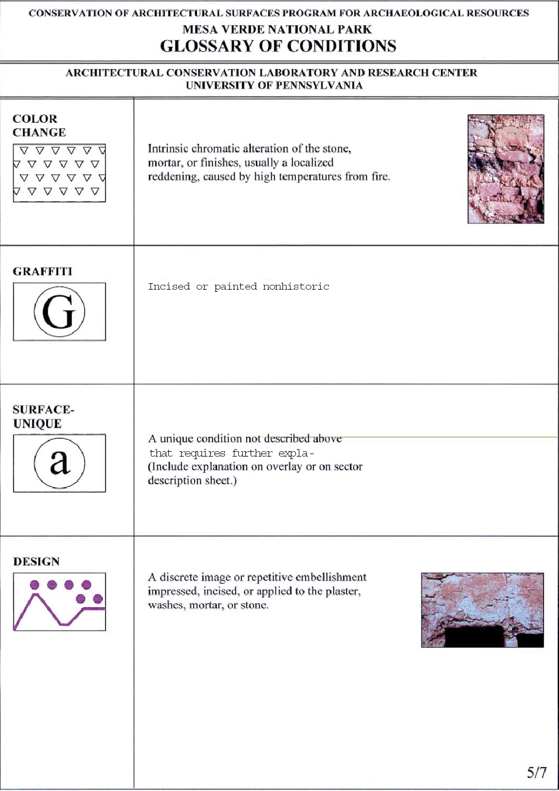
To borrow a much-used linguistic parallel, reading requires an understanding of word definition and grammatical construction, which determine and shape meaning. Meaning is a function of the original text and all the readings and interpretations of that text from the beginning. Similarly, with condition diagnostics, the process of understanding must begin with the construction of an understandable and reproducible language describing the evidence observed. In practice, many conservators underplay the subtle contributions that clear, descriptive conditions recording can bring to the causal interpretation and treatment of works. Once such a system is constructed, tested, and in place, the collection, management, and correlation of the data afforded by recent advances in digital technology can allow for sophisticated readings and flexible interpretations. This correlation can then be applied toward the development of a greater range of conservation treatment options and management strategies, including long-term monitoring and preventive conservation. All condition assessment surveys depend on qualitative and quantitative recording that describes the type, location (macro or micro), status (active or inactive), extent, and degree of severity for each condition observed. Wherever possible, this recording should be performed over time where photographic or other past descriptive information exists. The medium or format by which this recording is done depends on what is being described, the size and scale of the work, the degree of accuracy required, and the equipment, skill, and time available. The first step in recording any condition involves the use of a structured classification system and precise, exclusive language and graphics. Because many decay mechanisms can be caused by various and complicated scenarios involving intrinsic and extrinsic factors, and because similar symptoms may result from different causes or different symptoms from the same cause, simple descriptive terminology based on the clearly stated observation of discernible physical characteristics is always preferable during the initial survey process. In this way, observations can be recorded that are free from the causal implications often associated with many commonly used terms (e.g., spalling) and in a more useful manner before a fuller understanding of the problem can be gained through other subsequent or parallel investigative and analytical techniques. This process usually requires the creation of a defined and coherent terminology, often accompanied by photographic and schematic illustrations, and designated colors and graphic symbols for mapping conditions and materials. Classification schemes are usually designed to serve a specific end, be it in preparation for treatment or to monitor deterioration or intervention. They represent an artificial hierarchical typology of the variables observed that, when considered with other information, can be termed “pathography,” or the descriptive science of studying and recording physical conditions. Standardized nomenclature is a fundamental requirement for all scientific inquiry. Early on, Milton Bradley summed up the importance of standardization in his study of color and color systems, warning, “Where there are no standards there can be no measurements, and if … we have no measurements of effects, no records can be made, and hence no comparisons of results at various places and times, and consequently no discussion and little progress” (Bradley 1895, 5). Attempts to develop material conditions standards began with the creation of organizations such as the American Society for Testing and Materials (ASTM) in the early 20th century. However, such standards were developed for specific modern construction materials such as concrete, wood, steel, and paints and relied on simple definitions and photographic or graphic standards for the explication of type and severity of condition. The development of specific condition-recording standards for architectural conservation contexts occurred much later in response to individual need with the creation of institutionally based systems such as the recommendations of the standards committee for stone-based products (NORMAL) in Italy (1990) and the work 1.1 ARCHAEOLOGICAL SITES AND SURFACE FINISHESThe conservation of architectural remains at archaeological sites presents great difficulties in the development and implementation of resource management programs. Current practice in the conservation and interpretation of such sites attempts to maximize documentation and the retention of original material in situ while, at the same time, often requiring interpretation of the remains in a manner that is sensitive to their preservation as well as intelligible to the public. This aim poses a difficult problem for any structure in a fragmented state and especially for fragile elements such as painted plasters, which are best understood in their original context but also highly susceptible to deterioration and loss. Despite earlier practices of complete or selective removal of architectural plasters and finishes from ruins and archaeological sites, preservation and interpretation in situ are now ideologically the preferred solution, even if shelters or reburial are the only option. In situ conservation ensures the possibility of future studies of the whole resource and allows the opportunity to view the ruin as a once-complete structure. Surviving plasters with their finishes, in particular, contribute significantly to our understanding and appreciation of these architectural sites by providing additional information on aesthetics and technology, and possibly contributing to a greater understanding of architectural function, status, and meaning (fig. 2, see page 59). In addition, such surface finishes make tangible and human what otherwise might be incomprehensible to the visitor and scholar alike. 1.2 THE MESA VERDE PROJECTWith these issues in mind, the U.S. National Park Service and the Architectural Conservation Laboratory of the University of Pennsylvania began collaborating in 1994 to develop a model program for the study and treatment of the masonry and architectural surface finishes of the cliff dwellings of Mesa Verde National Park, a World Heritage Site in Colorado, in the southwestern region of the United States. The principal goals of the program have been to develop a comprehensive management system for the documentation and recording of these architectural components, to design and implement remedial and preventive conservation methods, and to integrate simple management practices into park maintenance so that further loss and damage of the prehistoric record can be prevented. Dubbed CASPAR—for Conservation of Architectural Surfaces Program for Archaeological Resources—this multiphased program has included a broad range of research and field activities, including architectural and condition documentation and recording, material analysis and characterization, condition survey, environmental monitoring, and treatment development, implementation, and evaluation. These activities have all been accomplished in the context of academic research and training. Despite the worldwide occurrence of earthen and masonry systems and their susceptibility to decay, no systematic program for their recordation or study as a discrete architectural component had been formalized (Matero 1999). One of the goals of CASPAR was to develop a comprehensive documentation and condition recording program whose objectives included:
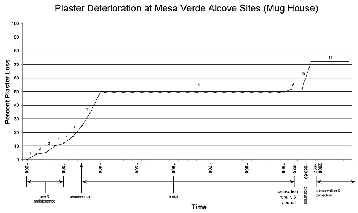
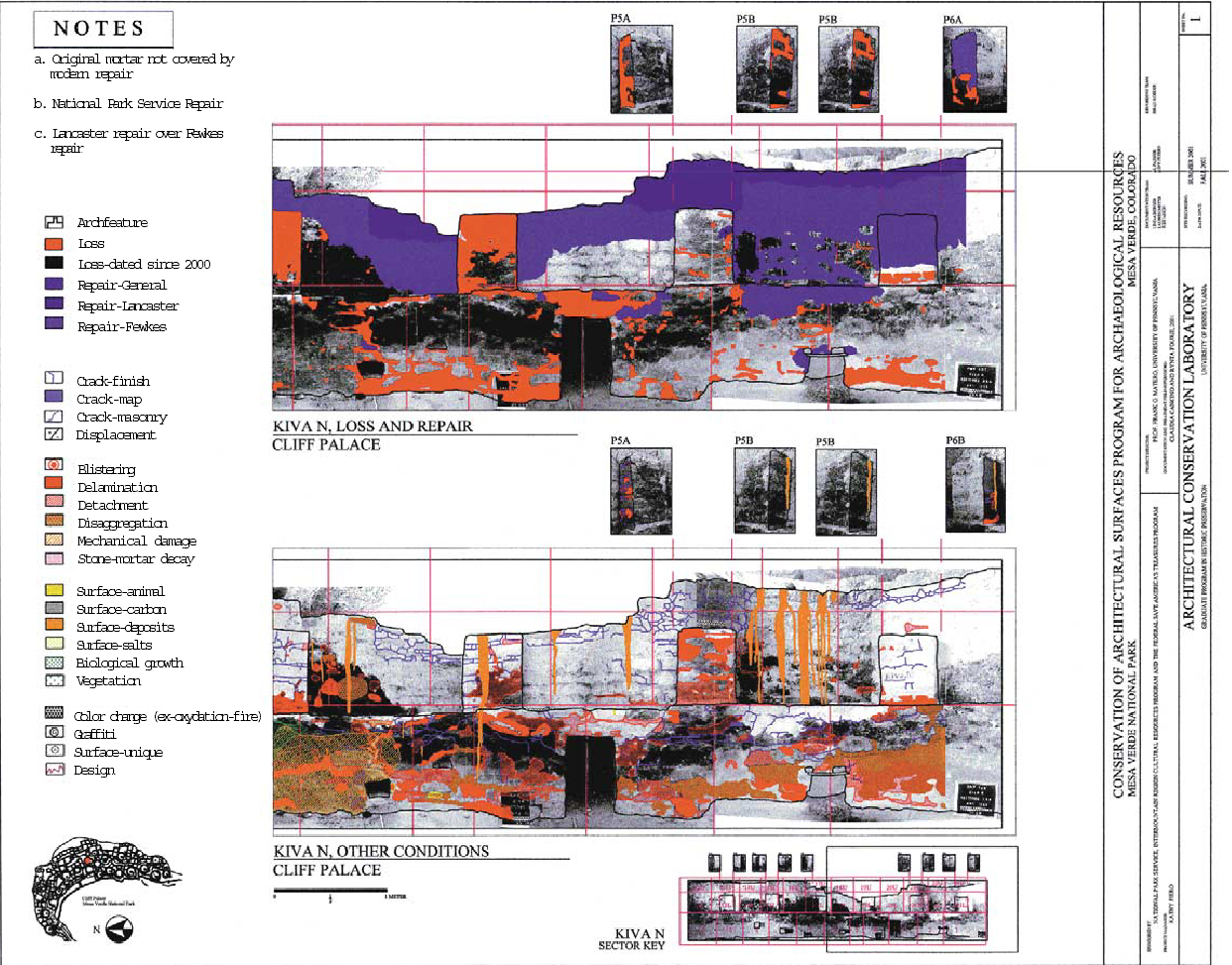
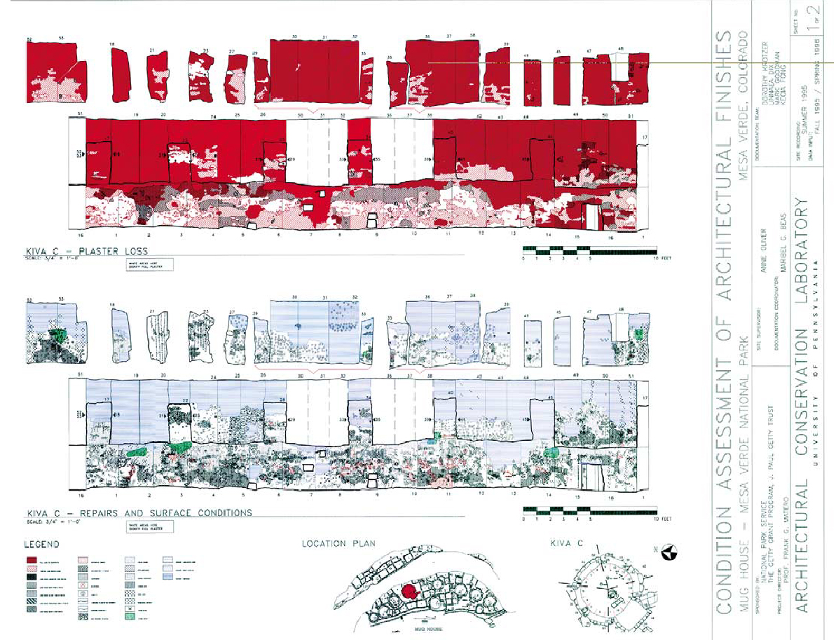
Over the course of seven years, the masonry and plasters within ten rooms and five kivas at Mug House and, later, five rooms and exteriors and five kivas at Cliff Palace were recorded by graduate students using the developed system. Mug House on Wetherill Mesa was selected as the model test site due to its moderate size (90 rooms and 8 kivas), high percentage of original wall fabric, and excellent documentation both before and after excavation and stabilization in 1959–60 by Arthur Rohn (fig. 3). Kiva C was chosen as the representative unit to be fully documented, with an architectural database and a 53-sector digitized graphic condition survey, due to the significance, extent, and poor condition of its mural paintings (fig. 4, see page 59) and the opportunity to reassess a previous pilot treatment program executed in 1981 by Paul Schwartzbaum and Constance Silver (Silver 1982). This condition survey, taken together with a compilation of the site's history of archaeological excavation and stabilization, a geological assessment of the alcove, the characterization and analysis of the plasters and surface finishes of Kiva C and Room 28, and the environmental data obtained through a two-year monitoring program (1996–97 and 1998–99), affords a more complete diagnosis of decay mechanisms than has yet been attempted at these alcove sites.
2 METHODOLOGY2.1 FIELD DOCUMENTATIONA sequence of field investigation and recording and off-site data processing was undertaken to document and assess the current conditions of two representative spaces in Mug House. While the details of any methodology are important to report for critical discussion and application, it is important to emphasize that the specific tools of the process—i.e., software and hardware—will change as a function of technological improvements. This development has certainly been the case in this and other projects, with the rapid innovations in applied digital information technology. What remains significant in the reporting of the methodology is the process itself: its goals, objectives, phasing, and ultimate diagnostic value for remedial treatment and preventive conservation for this and similar sites worldwide. 2.1.1 ARCHITECTURAL SURVEYIn preparation for the graphic recording of previous and existing conditions, a sector-by-sector architectural survey of each room or space containing surviving plasters and surface finishes was undertaken for Mug House and Cliff Palace and guided by a manual created for the project. Information recorded included masonry construction materials and techniques, with an emphasis on finishes typology, architectural features, and previous stabilization efforts for each area (see appendix 1, pages 64–67). Architectural terminology was developed in conjunction with park archaeologists to refine existing descriptive terms for Mesa Verdean and Puebloan architecture in general. A descriptive survey of architectural information was considered a necessary preface to condition recording for several reasons. First, by describing the architectural materials and construction, features, and repair campaigns for each space by architectural segment, surveyors visually educated themselves about the type, variation, and extent of the architectural fabric before recording the range of symptomatic conditions.3 Second, by observing and recording the variables of location, exposure, materials, construction, and previous repair with respect to condition, critical associations could be established early on that would aid in ultimately understanding the complexities of deterioration mechanisms and patterns. These field data were later manipulated using Access database software to test the role of related factors such as construction technique, exposure, and previous repair on existing condition. Detailed documentation of the architectural context of the surface finishes also assisted archaeologists in better understanding the original and subsequent application, use, and meaning of these finish materials in the context of their own work. 2.1.2 PHOTODOCUMENTATIONTwo hundred fifty individual photographic images were produced of the 10 rooms and 5 kivas at Mug House for the purpose of recording specific details of the conditions of the architectural surface finishes, including plain and painted plasters. An “ideal” image size, or surface area recorded in each photograph, was first determined to allow sufficiently detailed capture of subtle but significant conditions, such as map cracking, for further graphic annotation. This requirement will vary for each project depending on the specific conditions to be recorded, the degree of detail required, and the architectural configuration. At Mesa Verde, a total distance of 121 cm from the wall was established to ensure adequate overlap from one image to the other, accounting for areas of distortion normally occurring around the edges. Plumblines were hung to indicate in each image the determined 66 cm wide sector, while the top and bottom margins were delineated by the tops of walls and the ground surface accordingly, thereby allowing the architectural form to dictate to some degree the vertical dimension of the recording module. Equipment employed included a Pentax 28 mm perspective control “shift” lens mounted on a 35 mm single-lens reflex camera. While larger formats were originally considered in order to obtain what is commonly believed to be a finer image quality, they were found to be cost prohibitive both in the field and in postprocessing when utilizing photo–CD Initially several black-and-white films and a number of lighting scenarios were tested to determine the best approach in obtaining image quality and detail of the various plaster conditions. Kodak TMAX 100 black-and-white film was selected for the enhanced contrast required to accentuate certain surface conditions. One tall and one very small tripod were necessary for all the photodocumentation, not only to stabilize the camera when using the slower film speeds but also to produce consistent results throughout the recording process. Measurements were taken to find the exact center of each sector photographed and to determine the 121 cm distance from the wall. Use of the tripods with bubble levels ensured that the film plane was parallel to the wall each time to eliminate as much distortion as possible. Important to note, however, is that the inherent irregularities of the wall surfaces and curvature of the kiva walls dictated that these photographic images were only marginally rectified or scaleable. This limitation was not disabling, as the primary purpose of the photographs was to provide a background base image for overall dimensions and superimposed graphic annotation of conditions. Experimentation with supplemental lighting consisted of a small flash unit held away from the camera at an angle to produce a small degree of raking light. The high degree of irregularities in the wall surfaces could be either enhanced to show greater surface detail, or exaggerated so as to appear greater than they actually were. Light from the flash, in other words, can produce at least two conditions: the flattening out of some surfaces, effectively erasing the appearance of cracks and bulges, or an exaggeration of cracks and bulges so that they appear more severe than is actually the case. Each sector of wall was then photographed with natural light only and again with raking flash to allow selection of the most accurate or best representation of the surface conditions. On the average, however, only the images produced with the natural light were chosen for printing. A flash (or a slave on occasion) was used to fill in the very darkest areas of an image or to even out images with both dark and light occurring simultaneously. 2.1.3 CONDITION RECORDINGAll field recording of conditions (and eventual treatments) was executed with waterproof colored pens on Mylar overlays on 8 x 10 in. printed photo-images. Direct laptop data entry on-site was not practical due to the harsh environmental conditions, lack of electrical power, and limited budget. Graphic recording systems were developed using color and symbol to define discrete condition types and subtypes within each. Both linear and overall pattern symbols based on standard AutoCAD graphics were employed, depending on the condition category and type (see appendix 1, pages 64–67). For example, subtractive conditions such as loss, detachment, delamination, and cracking were represented with various linear patterns, while additive conditions such as various surface deposits and biogrowth were represented by overall dot patterns. Within general condition types, color and pattern were further refined, linking subtypes together and/or reflecting the different levels of severity within a type. For example, all subtypes of loss were represented in red, and repair campaigns were represented in blue. In other cases, graphic symbols were further refined so that linked subtypes were expressed as variations on a specific pattern such as diagonal hatching and cross-hatching for detachment and delamination and solid and dashed lines for various modes of cracking. In this way, a graphically compatible and easily legible classification system could be created, allowing a fast visual reading both within condition categories (same type) and across condition categories (different types) while at the same time referencing past conditions and previous treatments through complementary graphic overlays and notes. The result is a graphically meaningful and easily legible system based on color and symbol, and 2.2 DIGITAL DOCUMENTATIONAll field-recorded information was subsequently imported into computer photographic and drawing applications to transfer the field survey into a digital format. The final product is a series of plotted vector drawings within the traditional architectural format of scaled elevations and plans but with complex, discrete overlays of annotated conditions, past treatments, and the ability to quantify each condition. These could be produced with or without the raster photo underlays (figs. 5 and 6, see pages 59 and 60). In addition, all current treatments were recorded on the survey for correlation between condition and treatment method and for future evaluation of treatment efficacy.
Three well-known and available graphic and database software programs were selected based on their compatibility, ability to process and analyze the data, and ease of manipulation and retrieval of the data combining graphic, textual, and numeric data. Adobe Photoshop was used to manipulate the CD-ROM raster image, combining and refining the photo elevations of each space. Selected negatives from the 35 mm black-and-white base images used in the field survey were scanned onto a CD-ROM. This process was performed by a commercial photography laboratory producing high-resolution images. Using Adobe Photoshop, the individual sector photographs were manipulated to correct perspective, crop images, and change contrast and sharpness where necessary to produce a good base image for the conditions graphic overlays. All individually entered sectors were then joined to complete each elevation. Joining and rectifying the photographs as a complete montage elevation should always occur first, before detailed sector recording of conditions is attempted, so that anomalies (e.g., misalignment, perspective distortion, or contrast) can be corrected on the base photographs and allow for accurate conditions overlay on the sector photographs at any scale (i.e., individual sector or entire elevation). Drawing programs were used to trace the architectural elements and the conditions. Drawing programs read both raster and vector images and therefore translated the information from raster photographs into vectored drawings. To date, two software programs have been used to import the raster photomontages from Adobe Photoshop into AutoCAD: Spittin' Image (in 1995) and, currently, CADOverlay. Compatibility between software is critical from the onset. Through these programs, architectural elements and surface conditions were traced over the photographs, as was done with the Mylar overlays in the field survey. Depending on site conditions and budget, conditions recording can be done directly in the field on laptop computers. Finally, AutoCAD was used to manipulate the data, assemble all sections, and create architectural drawings to scale. AutoCAD is a graphics software that allows architectural formatting, scaling, and presentation. In this program, the individual sectors were pieced together to form panoramic images or “roll-outs” of the walls of the kivas and individual wall elevations for rooms and open areas. AutoCAD also enabled the display of multiple layers of conditions in any combination simultaneously. The photomontage underneath provided a comprehensive visual representation of the surfaces and spaces, allowing further complex analysis of patterns of deterioration relative to location and orientation within the entire space. Quantification of individual conditions as surface area was performed in AutoCAD and imported into the database program Access. The created database has allowed the quantification of conditions by location and type and will allow future study and tracking of deterioration through time. The field survey data were also transcribed into the database, allowing conservators to test the relationships between condition and deterioration and the variables of original design, materials, construction, exposure, and past interventions. 3 DIAGNOSIS: WHAT THE EVIDENCE SUGGESTSThe breakdown of conditions recording into discrete, symptomatic descriptions allows for the The overall recording of conditions in the context of supporting documentary information such as past uses, treatments, maintenance, etc. allows a working prognosis or prediction of causes, trends, patterns, and significance. These can later be supplemented and confirmed using other methods of investigation and analysis that lead to the point of diagnosis. The following observations are a summary of the major conditions recorded for Kiva C, Mug House, during the field survey from 1995 to 1998. When considered in conjunction with other factors such as environment and microclimate, wall orientation and exposure, wall composition, construction technology, and previous interventions, these observations suggest a complex etiology for building and material performance and failure through time. The summary observations described below are intended to accompany and supplement the graphic data provided as printout and on screen and are organized by condition type (see fig. 6, page 60). In this way, multiple interpretations of conditions can be explored to reveal patterns and trends as well as anomalies related to time, location, and condition type. With the application of “smart” mapping programs such as ArcView, predictive modeling of conditions as indicators of future damage can offer expanded analysis and opportunities for better risk assessment for cultural resources at any scale. Although definitive statements confirming the various mechanisms and rates of deterioration observed at Mug House, and specifically for Kiva C, must be deferred, at least until the environmental monitoring data have been finalized, several general correlative observations can be made on the basis of the visual survey and the architectural design and construction, and materials analysis and characterization of the mortars and surface finishes:
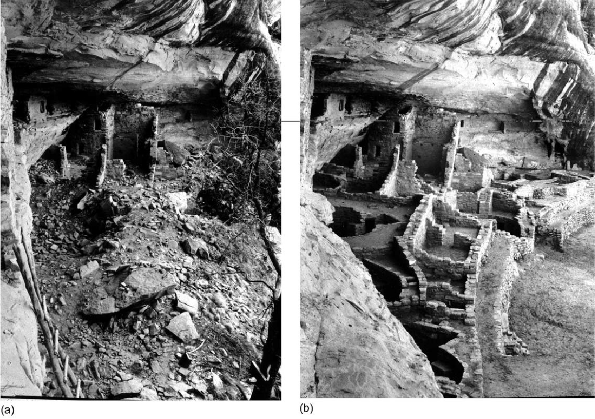
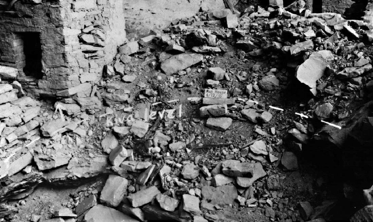
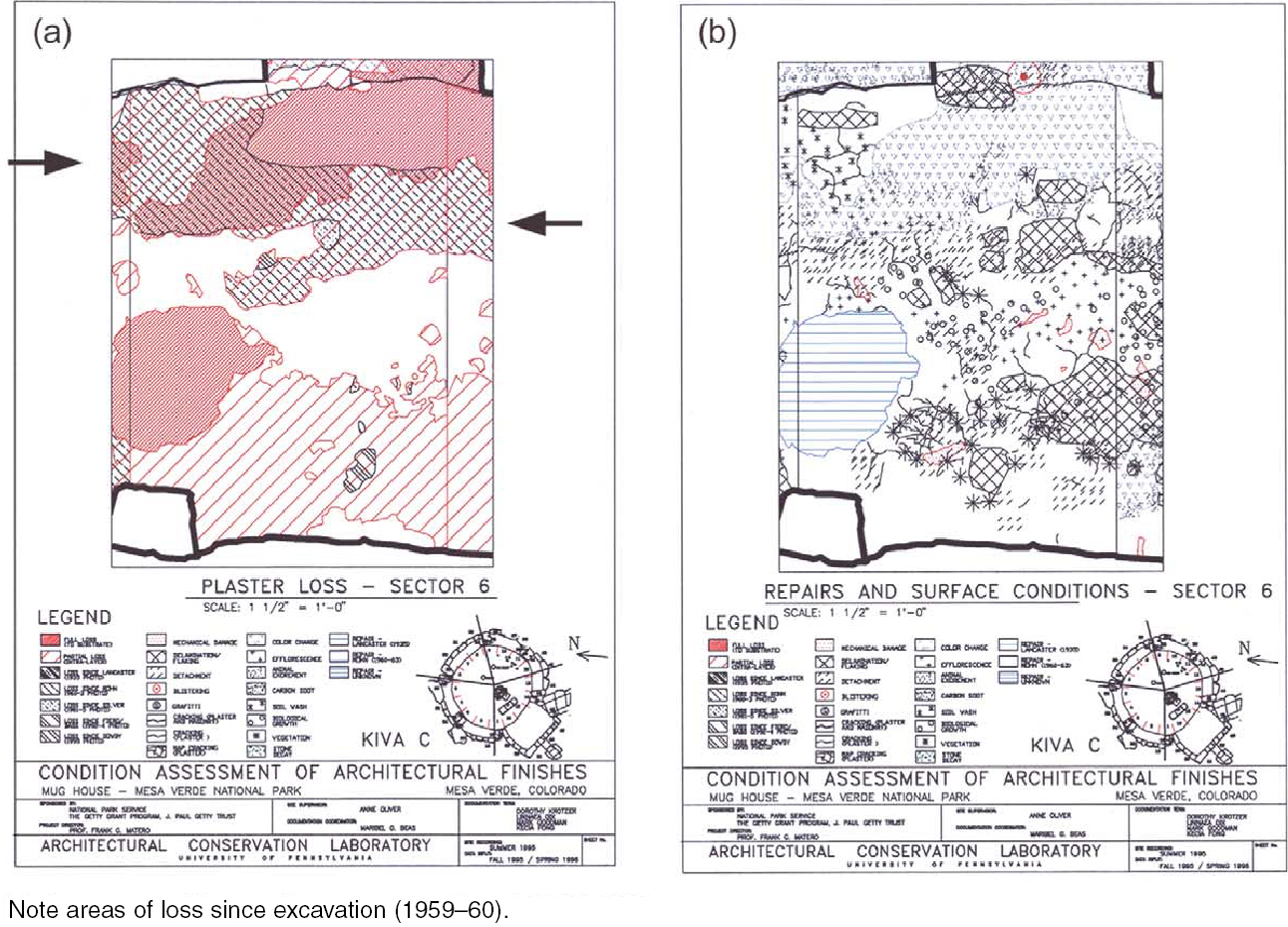
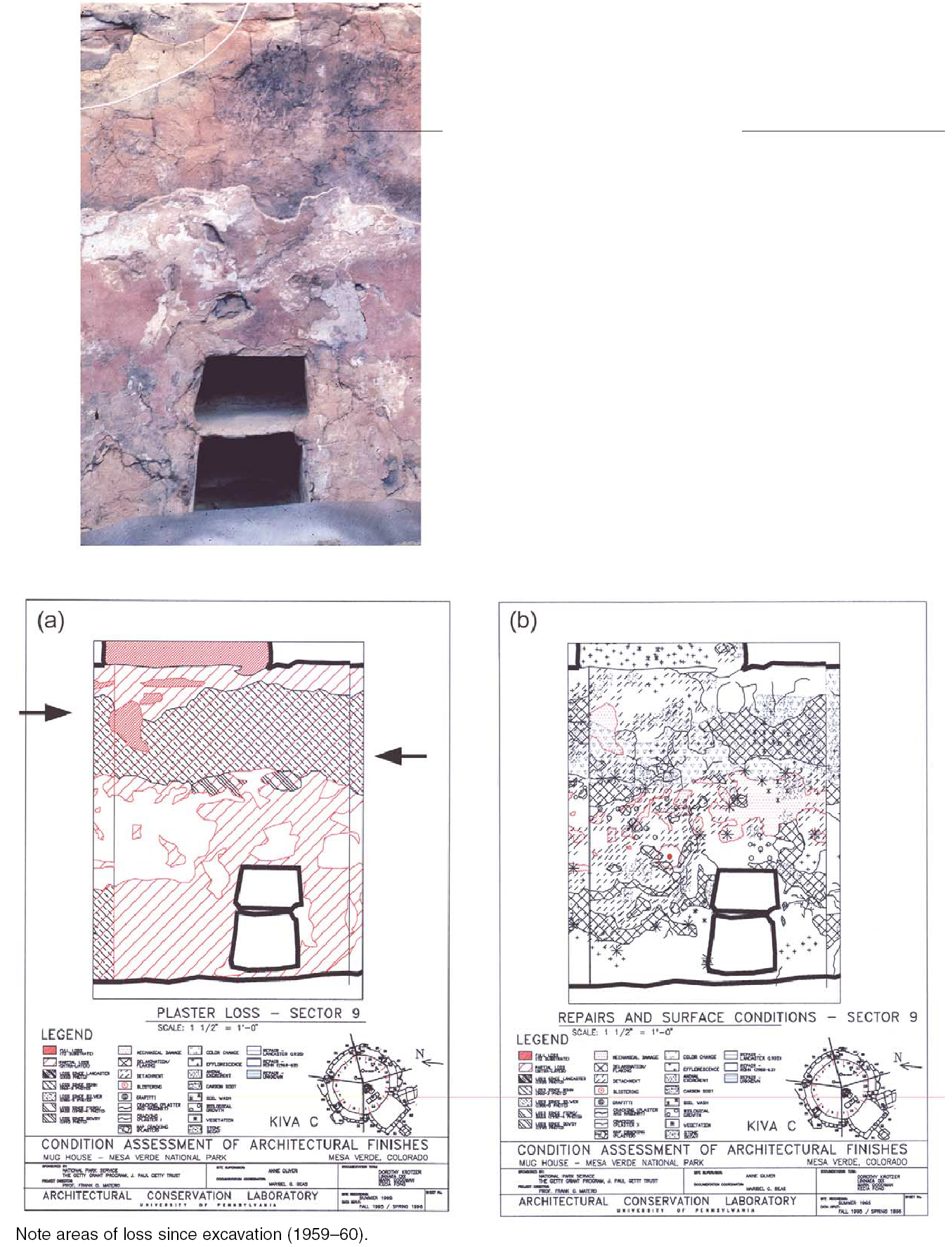
A more detailed analysis of the observed conditions in Kiva C, discussed below by type (see appendix 1, pages 64–67), suggests various patterns and trends linked to the specifics of the above determinants. 4 SUBTRACTIVE CONDITIONS4.1 LOSS/PARTIAL LOSSTotal loss is the final and ultimate stage of deterioration for surface finishes. It is the most extreme condition and obviously nonrecoverable; however, the careful recording of total and partial loss is a useful indicator of past and current patterns and trends, especially when datable through earlier photodocumentation. When viewed in conjunction with partial loss, active deterioration characterized by specific conditions such as detachment, delamination, and flaking can be understood as the preface to total loss. In Kiva C (and most other kivas), nearly all loss has occurred across the upper walls and along the upper quarter of the lower banquette walls (fig. 8, see page 61). This loss pattern is due to the overall vulnerability of these areas to weather exposure during occupation from roof leaks (prehistoric repairs are often found in the upper walls), after abandonment from associated roof collapse, and after excavation and rebuilding during stabilization. Early prestabilization photographs of Kiva C (1935) show masonry and roof collapse, exposed upper walls, and total plaster loss (fig. 9). The lower banquette walls—being concealed and possibly protected by fallen roof and debris—were observed in 1935 to be generally intact, a situation common for many kivas in cliff sites. A comparison of the extent of surviving plaster evident immediately after excavation and stabilization in 1959–60 to today overwhelmingly illustrates the loss of plaster that often results after excavation. At Kiva C more than 25% (surface area) of the existing plaster finishes recorded in 1960 was subsequently lost over the next 40 years of exposure, most of the loss occurring along the upper banquette.
Most partial loss also occurs along this upper banquette wall face, often directly below areas of total loss, as well as along the base of the banquette (fig. 10, see page 61). Conversely the entire middle zone of the banquette walls retains the most complete finishes, especially on the pilasters. This pattern—although dependent on the specifics of room orientation, namely exposure and proximity of the space to the alcove's rear wall, surrounding wall height and configuration, and the number of superimposed finish layers—generally reveals the critical relationship among design, construction, and weatherability. The finishes on the walls directly under the flat banquette ledges between the pilasters succumb to the wind-driven rain and melting snow that accumulate on these flat, horizontal upper surfaces along the outer west and northwest sections. This pattern of precipitation has been observed in action and can be deduced from the succession of related conditions along the upper banquette wall, beginning at the top with total loss and detachment and deformation of the remaining plaster edges, to partial loss and delamination lower down the wall. The telltale evidence of new and old soil wash patterns in these locations down the upper and lower walls (monitored over two years) clearly points to active water flow channeling. This activity leads to the probable sequence of plaster decay including saturation, swelling, and shrinking of the clay fraction of the finishes, salt formation, deformation, blistering and detachment of the layers, debris accumulation in the detachment, and eventual mechanical failure and loss. These conditions have been recently induced in sequence through laboratory simulation in preparation for treatment testing and evaluation. Changes in partial loss over time clearly indicate the active nature of this condition in exposed areas (Carr 2002). Conversely, the lower eastern walls along the rear of the alcove display less differential damage relative to the banquette shelves and no soil wash, presumably due to the protection afforded by the extreme depth of the alcove (fig. 11, see page 62). However, what can be observed along the lower rear walls is severe delamination and flaking, salts, and intralayer root masses, the latter responsible for post-1960 loss of the last dado layer along the upper banquette wall. These conditions suggest typical moisture problems related to cyclical wetting from driving rain and snow and frequent thermal cycling. In fact, Kiva C is uniquely situated in the alcove so that its western half experiences prolonged wetting directly from rain and melting snow captured on the banquette tops, while its eastern half experiences some direct wetting from heavy precipitation events. In addition, sulfate and
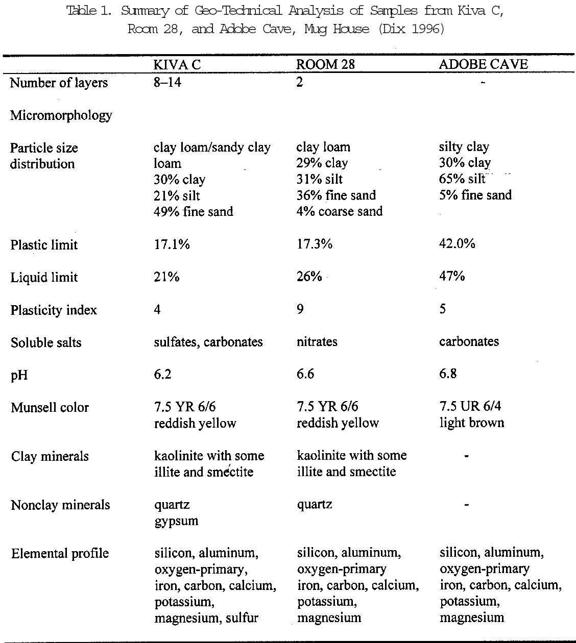
Overall patterns of groundwater emergence for the entire alcove are further complicated by the orientation of the north-south dip of the alcove's shaley layers, which affects the location and quantity of water emerging from the rock. For example, those kivas and rooms located along the rear of the northern half of Mug House, upslope of the shaley seam, exhibit far more salts, presumably due to the initial discharge of water at this end. Conversely, rooms along the rear of the southern half, downslope of the shaley seam, display less efflorescence and water damage where protected from wind-driven rain and snow. Based on this evidence, room location within the alcove—especially as it relates to rear wall moisture determined by the activity of water percolation and the orientation of the shale seam, subterranean ground elevation, as well as exposure to the weather—is critical in determining plaster conditions. No doubt the immediate physical context of each space, such as the surrounding wall heights, creates unique climatic environments for each architectural feature and associated surface finishes. Nevertheless, the specific combinations of conditions observed in Kiva C at Mug House reveal the importance of siting within the alcove and the complexity of primary and secondary factors in the explanation of basic decay mechanisms (see fig. 7, page 60). After environment, composition and layer structure of the finishes, in association with the deposition of carbon soot and embrittlement from intense burning, play an important role in determining condition. All surface finishes examined thus far reveal a well-proportioned ratio of kaolinite-illite clay binders to a fine but well-graded and sorted silt and quartzitic sand fraction, thus ensuring initial good adhesion and low shrinkage of these finishes (Dix 1996, 88–90) (table 1). Cryptocrystalline calcite found in the soil used to prepare the plasters and also possibly deposited subsequently from bicarbonate-rich groundwater helped to give good durability to these finishes. The possible presence of organic plant additives, as recorded in late-19th-century ethnographic accounts, could have also provided short-term durability,
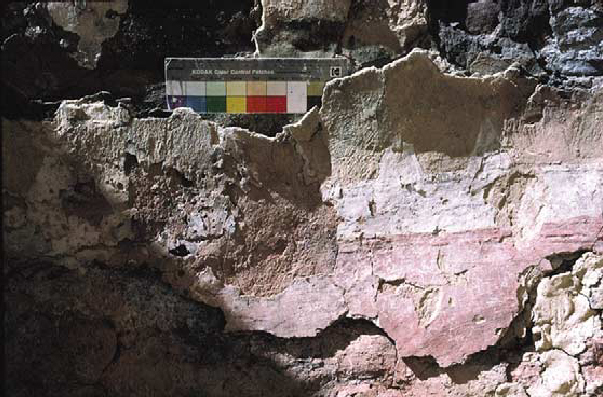
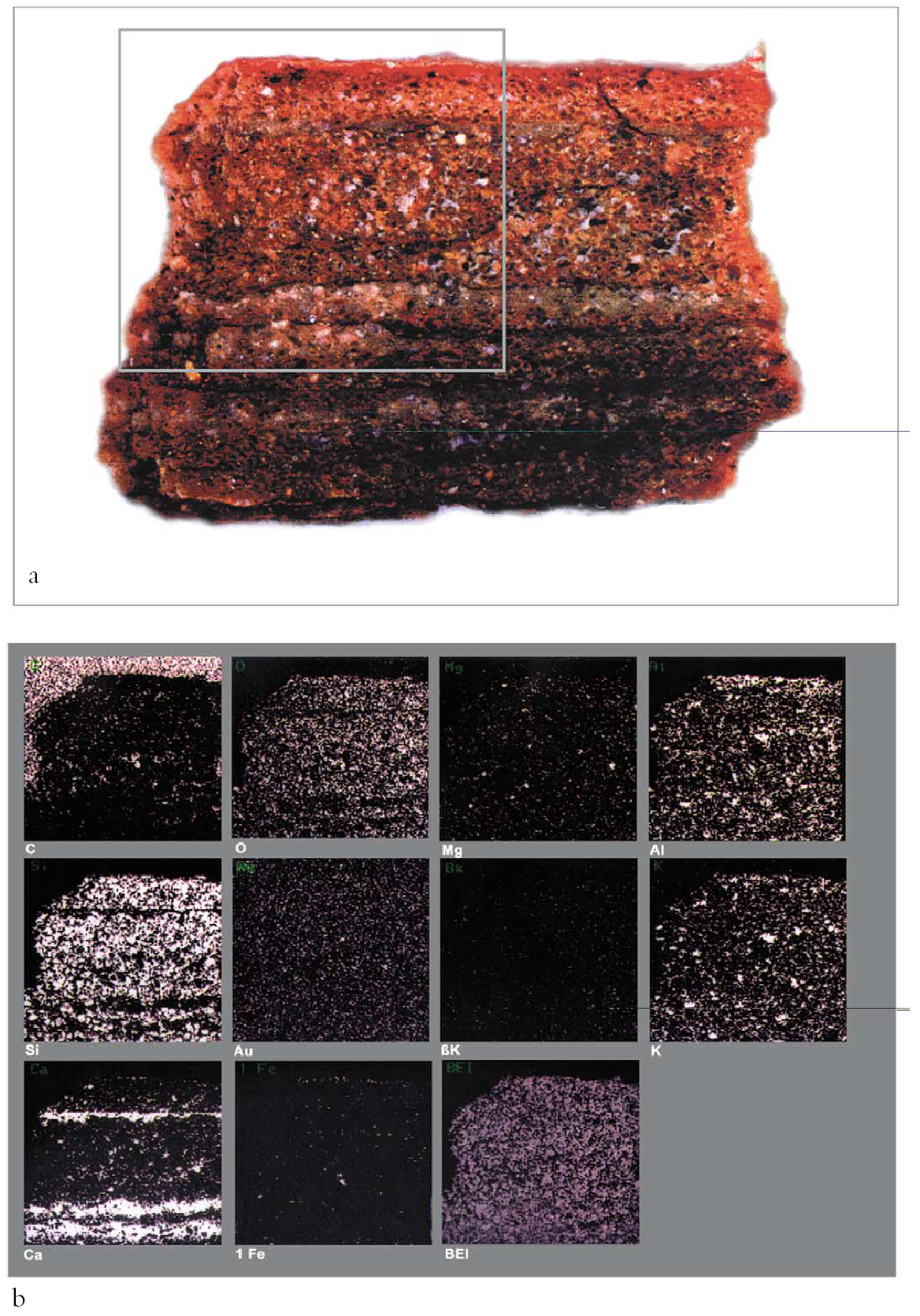
Layer structure, and indirectly masonry construction, is without doubt a significant factor in finish condition. With very few exceptions, each plaster layer applied probably represents a single campaign, evidenced by heavy carbon soot buildup and separation fractures that often occur between layers over time. Of all the building and room types, kivas, without exception, contain the greatest number and most complex application of surface finish layers and intralayer soot deposits (fig. 12, see page 63). This condition may well be due to the largely ceremonial
Given the weak and brittle nature of these earthen finishes (when dry), layer stability is generally inversely proportional to the number of layers applied to the surface. As with other plastered masonry, the earthen finishes adhere best to the earthen mortar joints regardless of keying, and less well to the stone. Intralayer delamination often results from poor adhesion caused by carbon soot deposits at these interfaces. Once detached, salts and roots find ideal environments to develop further, thus exacerbating the problem of delamination, salt formation, and moisture retention. At Mug House, most kivas are carefully constructed with regular, well-shaped, and finished stones, especially for the pilasters and lower banquette wall. This construction has the effect of ensuring a smooth, curvilinear surface upon which to apply the numerous thin earthen plasters and washes needed to complete the architecture.4 Only Kiva C, whose masonry is roughly shaped, finished, and coursed, has a thick initial leveling plaster of several centimeters applied to the masonry substrate and followed by subsequent thin finish plasters and washes, some of which appear to have been burnished (lower red dado). As a result, this construction technique has caused unique detachment problems in Kiva C, given the vulnerability of the thick base plaster. 4.2 DELAMINATION AND FLAKINGA subset of partial loss characterized as active surface (flaking) and intralayer (delamination) failure has been found extensively along the lower banquette walls, especially in combination with salts and previous root growth. 4.3 DETACHMENTLoss of bond between the plasters and their masonry substrate occurs as either open or blind separation. This loss is found as a narrow linear zone across much of the upper top edge of the lower banquette wall. It is a discrete condition often occurring in conjunction with total or partial loss since excavation (recorded as “loss since Rohn”; see fig. 6, page 60) due to exposure and failure resulting from wet/dry deformation and stress cracking, debris accumulation pressure, and falling damp. 4.4 BLISTERINGThe wetting, swelling, delamination, and subsequent deformation of thin single or multiple layers of plasters and washes result in the formation of blisters of variable sizes and shapes. Often these exist in various stages as blind, cracked, and broken forms, always in locations where water has been or still is present. Although this condition is prevalent in other spaces, its occurrence at Kiva C is very limited. 4.5 CRACKINGNo major structural failure exists in Kiva C, although some cracking is related to previous joint and masonry movement that has been translated to the plasters. Map cracking occurs in isolated areas, particularly the lower rear wall in association with root mass–related delamination. There is no evidence to suggest that this map cracking was caused by initial shrinkage of original plasters. However, areas of repeat wetting and drying indicate stress failure in the form of map cracking. 4.6 MECHANICAL DAMAGEMechanical damage occurs in isolated areas, especially along the lower walls as random scratches that appear to be due to animal activity and as small divots from the inadvertent strike of the excavators' trowels into the plaster. This damage is not related to any other conditions. 5 ADDITIVE CONDITIONS5.1 SOIL WASH AND RUNNELSSoil wash occurs as a thin wash of tan-brown soil or deep runnels extending downward from the upper wall edges and banquette ledges. Soil wash flows down the surface according to divots and jogs in the upper masonry. The recording of variations in the soil wash patterns over two years within the same areas confirms an active condition of water runoff along the western edge of Kiva C, especially in the keyhole and to the north. Active loss and areas of detachment, delamination, and deformation along the upper plaster edge of the banquette walls are all found in association with soil wash and runnels above. 5.2 EFFLORESCENCENaturally occurring carbonates, and to a lesser degree sulfates, constitute the major soluble salts present at Mug House. Salts are clearly visible as discrete nodules in the bedding mortar and stone in areas of high moisture saturation both along the front and the rear, depending on the source of moisture. Salt cycling appears to be more severe along the front wall, where summer rains and melting winter snow cause dissolution and recrystallization within these materials. As a result, both stones and mortar in areas along the upper banquette walls to either side of the pilasters display considerable efflorescence and decay due to repetitive, prolonged wetting from melting snow and rain. 5.3 COLOR CHANGEColor change is most characteristically observed as a localized reddening of the plaster, mortar, and stone, most intense on the surface and gradually diminishing with depth. This color change is caused by the calcination and oxidation of the iron-containing minerals in the clays. Fire reddening occurs exclusively along the upper half of the banquette walls and especially on exposed stones that were covered by plaster visible in the 1960 Rohn photographs and now missing. Burning may have embrittled the plasters (as in Kiva B), resulting in loss through weathering. The location of the fire reddening along the upper half of the banquette wall suggests burning may have occurred after abandonment and roof collapse that might have protected the lower walls. 5.4 CARBON SOOTThe location of carbon soot staining at Kiva C complements the locations of fire reddening. That is to say, carbon soot blackening occurs on the upper walls of in situ stone and plaster fragments above the fire-reddened areas and not on the last plaster layer along the lower banquette wall. Continuous thick overall carbon soot application has also been found on elements in some kivas and rooms that appear to have been selectively exposed in combination with the application of colored washes. These situations suggest the conscious application and/or manipulation of carbon-sooted surfaces as a design element. 5.5 VEGETATION AND BIOGROWTHNo active plant growth currently exists in Kiva C; however, ample evidence exists in the form of dead root masses between plaster layers along the rear lower wall. Root growth preference between the plaster surface and the fill is evident from mineral root pseudomorphs on the surface of the plaster. These are calcium deposits leached and redeposited by the plant over time, replicating the form of the original root. Evidence of both forms of growth along the rear wall can be attributed to the moist conditions along the rear alcove and the presence of a favorable growing medium from the deteriorated wet plaster. Biogrowth or microflora of fungi and lichens also occurs in limited and isolated locations in all cases associated with previous or current areas of moisture. 5.6 PREVIOUS REPAIRSAt least six repair campaigns were identified at Mug House, the first beginning in 1935 by Earl Morris and Al Lancaster. With the full excavation of 6 CONCLUSIONSOnce the Mug House project was established as a model for future conservation at Mesa Verde National Park, the next step was to develop a comprehensive survey program for recording the surface finishes in the more than 600 alcove sites. In 1998 a priority treatment assessment program was initiated by park conservators to establish a prioritized treatment schedule for the remedial care and long-term preventive conservation of these neglected components in select front- and backcountry sites. The program also was designed to provide a management strategy for parkwide planning and budgeting for future conservation work. This survey builds on previous surveys conducted in the 1980s (Silver 1985; Fetterman and Honeycutt 1989; Bohnert 1991) by numerically ranking each room/space and unit for proposed treatment according to detailed physical condition, relative importance or significance, and public accessibility. Data are entered into an Access database where architectural, condition, and treatment information can be queried. From 1998 to 1999, nine alcove sites with more than 760 walls were assessed and assigned a treatment priority rating based on the criteria above. Ninety-one walls, or nearly 12% of the elevations surveyed, at an approximate total of 375 square meters, have a high priority for treatment. Treatment priority location maps for each site and treatment schedules based on the Mug House pilot program have been made for each of the high-priority walls. In addition to this parkwide finishes reassessment program, the Mug House pilot program was applied to study and ultimately treat the most-at-risk architectural surface finishes and mortars of Cliff Palace, one of the best known and largest cliff dwellings in the United States. Remedial treatments for detached finishes and temporary site protection methods were developed according to a parallel research program based on the analysis of the condition survey, finishes characterization, and environmental monitoring. Mesa Verde is public heritage whose care and interpretation are entrusted by law to the National Park Service, and future research and continued public enjoyment of this park must be guaranteed. Given its uniqueness and world-class significance, any conservation measure considered must be evaluated against the physical changes that will result from its implementation now and in the future. To this end, continued site investigation and survey, environmental monitoring, and judicious treatments based on an easy, accurate, and reproducible system of conditions recording can be recommended as the most responsible and appropriate method toward developing, implementing, and modifying, over time, a cultural resource management plan. ACKNOWLEDGEMENTSMany graduate students and consultants participated in the Mesa Verde documentation and conservation program. Those contributing to development of the documentation process included Maribel Beas, Claudia Cancino, John Fidler, Kecia Fong, Rynta Fourie, David Myers, and Jeanne Marie Teutonico. The photodocumentation method was developed and executed by Katherine Dowdy, documentation archaeologist, specifically for the project, and the parkwide survey was developed and conducted by Kathleen Fiero, Ann Oliver, and Angelyn Rivera for Mesa Verde National Park. NOTES1. Documentation is addressed in most international and national conservation charters. See, for example, 2. By “standard” I mean a reference point. In the case of conditions classification systems, a standard implies developing a consensus among professionals on both the general meaning of specific conditions terminology and an agreed-upon order to that system and its graphic representation. Standard terminology is common in other scientific disciplines, such as geology and cartography, and allows for better communication among professionals. Standards and standardization do not and should not attempt to restrict definitions or fix specific conditions with specific causes. 3. At Mesa Verde, spaces were divided into “segments” to define a practical architectural unit, e.g., banquette, to which quantitative and qualitative descriptions could be assigned. In contrast, conditions were recorded on “sectors” or area units created by the superimposition of an abstract grid over the architectural surface. 4. At Mesa Verde, “plasters” are defined as discrete finish layers greater than 1 mm in thickness; “washes” are discrete colored finish layers less than 1 mm thick. This visual classification according to thickness is reinforced by consistent distinction in granulometry, suggesting an original understanding of the use, if not formulation, of plasters and washes based on observed performance characteristics. REFERENCESAshurst, J., and F. G.Dimes. 1990. Conservation of building and decorative stone, vol. 1. London: Butterworth-Heinemann. 179–84. AIC. 2001. Code of Ethics and Guidelines for Practice. Approved 1994, Documentation Articles 24-28 and Commentary 24, 25, 27, and 28. In Directory of the American Institute for Conservation of Historic and Artistic Works. Washington, D.C.: American Institute for Conservation. Beveridge, W. I. B.1957. The art of scientific investigation.3d ed.New York: Random House. Bohnert, A.1991. Proposed action plan covering prehistoric earthen plaster at Mesa Verde National Park. Unpublished typescript report. Mesa Verde National Park, Mesa Verde, Colorado. Bradley, M.1895. Elementary color. Springfield, Mass.: Milton Bradley Co. BrownIII, M. R., and E. C.Harris. 1993. Interfaces in archaeological stratigraphy. In Practices of archaeological stratigraphy, ed. E. C.Harris, M. R.BrownIII, and G. J.Brown. London: Academic Press. 7–20. Carr, R.2002. Evaluation of adhesive binders for the preservation of in-situ aboriginal surface fnishes at Mesa Verde National Park. M.S. thesis, University of Pennsylvania. Dix, L.1996. Characterization and analysis of prehistoric earthen plaster, mortars, and paints from Mug House, Mesa Verde National Park, Colorado. M.S. thesis, University of Pennsylvania. Dowman, E. A.1970. Conservation in field archaeology. London: Metheun.
Fetterman, J., and L.Honeycutt. 1989. The 1987 Mesa Verde plaster recordation project. Unpublished typescript report. Mesa Verde National Park, Mesa Verde, Colorado. Fewkes, J. W.1909. Antiquities of the Mesa Verde National Park, Spruce Tree House, Smithsonian Institution. Bureau of American Ethnology Bulletin 41. Washington, D.C. Fitzner, B., K.Heinrichs, and R.Kownatzki. 1997. Weathering forms at natural stone monuments: Classification, mapping and evaluation. Internationale zeitschrift fur bauinstandsetzen3:105–24. Grimmer, A. E.1984. A glossary of historic masonry deterioration problems and preservation treatments.Washington, D.C.: Department of the Interior, National Park Service. Harris, E. C.1989. Principles of archaeological stratigraphy. 2d ed.London: Academic Press. Matero, F.1999. Lessons from the Great House: Condition and treatment history as prologue to site conservation and management at Casa Grande Ruins National Monument. Conservation and management of archaeological sites3:203–24. NORMAL. 1990. Raccomandazioni NORMAL 1-88: Alterazioni macroscopiche dei materiali lapidei—lessico. Rome: Istituto Centrale per il Restauro. Palumbo, G.2000. Beyond CAD: A look at data integration and analysis using GIS. In GRADOC: Graphic documentation systems in mural paintings conservation. Rome: ICCROM. 114–24. Schiffer, M. B.1996. Formation processes of the archaeological record. 2d ed.Salt Lake City: University of Utah. Silver, C.1982. 1981 report on the development of methods for the conservation of Pueblo Indian mural paintings in the American Southwest. Unpublished typescript. Mesa Verde National Park, Mesa Verde, Colorado. Silver, C.1985. Summary of the results of the 1985 project: Survey of plaster and rock art at Mesa Verde National Park. Mesa Verde National Park, Mesa Verde, Colorado. UNESCO. The International Charter for the Conservation and Restoration of Monuments and Sites (The Venice Charter). AUTHOR INFORMATIONFRANK G. MATERO is associate professor of architecture and chair of the graduate program in historic preservation at the Graduate School of Fine Arts, and director and founder of the Architectural Conservation Laboratory and Research Center at the University of Pennsylvania. He is also a member of the Graduate Group in the Department of Art History and is research associate of the University Museum of Archaeology and Anthropology. He is visiting lecturer in the professional course on Architectural Conservation at the International Center for the Study of Preservation and the Restoration of Cultural Property (ICCROM) in Rome and at the Department of Architecture, Polytechnic University of Puerto Rico. He is also a senior lecturer for Restore, New York City. Matero's teaching and research are focused on historic building technology and the conservation of building materials, with an emphasis on masonry and earthen construction, the conservation of archaeological sites, and issues related to preservation and appropriate technology for traditional societies and places. Publications include articles in numerous professional journals, conference proceedings, book chapters and two forthcoming books on the technical history of the stone industries of North America, and a history of archaeological site preservation in the American Southwest. He has consulted on a wide range of conservation projects including the Ayyubid wall of Cairo, Drayton Hall, the Guggenheim Museum and Trinity Church in New York, the Lincoln and Jefferson Memorials, Ellis Island, the above-ground cemeteries of New Orleans, and the archaeological sites of Mesa Verde, Casa Grande, Bandelier, and �atalh�y�k in Turkey. He is regional editor for Conservation and Management of Archaeological Sites and the Journal of Architectural Conservation. Matero is a Professional Associate of the American Institute for Conservation of Historic and Artistic Works and former co-chair of the Research and Technical Studies Group. Address: Graduate Program in Historic Preservation, Graduate School of Fine
 Section Index Section Index |